Hack 85 Map the Wireless Landscape with NoCat Maps
|
Manage many wireless nodes with this open source mapping project. In addition to commercial tools like Topo! and the DeLorme map software [Hack #80], there are a number of freely available mapping solutions that make use of public GIS data. While there is a huge amount of data available about the surface of our planet, most of the tools used to query and view the data are far from simple. The NoCat Map project combines two powerful GIS programs to build a sophisticated but easy-to-use node database. It is built on MapServ (http://mapserver.gis.umn.edu/) and Grass (http://grass.itc.it/), and is available at http://maps.nocat.net/. NoCat Maps integrates the data and rendering functionality of MapServ and Grass with a simple node database, and attempts to provide useful data and visualization from the result. Users can add data for their own equipment, including latitude, longitude, altitude, and contact information. If this data isn't known ahead of time, it can make an approximate guess from the user's mailing address. This data can then be queried and compared to other nodes in the database to find likely point-to-point links. You can then select a node from the database and view the likeliest links in a simple table, as shown in Figure 6-4. Figure 6-4. View likely point-to-point links at a glance.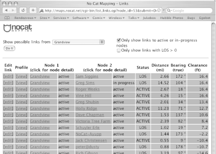 Since the position of each node is known, the distance and bearing can easily be calculated. By consulting the GIS data for the land elevation between the two nodes, a minimum clearance can also be estimated. This can be shown graphically by clicking on the "View Profile" link. Figure 6-5. One possible point-to-point link.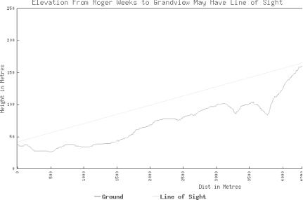 Figure 6-5 shows the profile of a possible link between two points. Note that just as with other tools that rely on GIS data, this shows the lay of the land without any indication of ground clutter (buildings, trees, etc.). This is good enough to go on for a rough estimate, and is especially helpful for eliminating definite impossibilities (Figure 6-6). Figure 6-6. This is not the link you are looking for. Move along.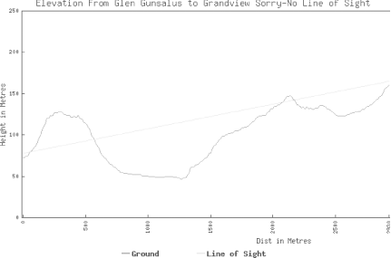 NoCat Maps is a work in progress, and currently supports only data for Sonoma County, CA. However, the source code is freely available, as are the data sets for just about every location in the U.S. If you are looking for an inexpensive method for managing a large number of outdoor point-to-point links, this software could be just what you want. |
EAN: N/A
Pages: 158