Creating Image Maps
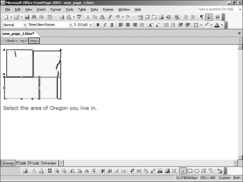
| An image map is a graphic with a number of hyperlinks associated with the graphic that lead to different places within a Web site. Image maps are usually used for navigational purposes and are quite time-consuming to code by hand. In Figure 16.14, a Web page with a map of Oregon is used to determine the location the user is interested in. TIP Image maps are also pretty much pointless for any browser that can't support images and image maps. If you are going to use image maps as a navigational element, remember to also include a navigational option for browsers that won't support the technology. FrontPage makes the development of image maps very easy through the Select and Hotspot buttons found on the Pictures toolbar. Use these tools to define an image as an image map and then draw the area with the hotspot drawing tools. Once the hotspot is drawn, FrontPage will open the Insert Hyperlink dialog box, providing the means to embed the hyperlink into that area of the graphic. If you need to edit an existing hyperlink or hotspot, double-click the area with the Select tool. In the Oregon image map (seen previously in Figure 6.14), the image was divided into four hotspots. Figure 6.14. The Oregon graphic is divided into four hotspots each leading to a different URL.
NOTE Image maps are a considerably older technology seldom used now because of accessibility and browser compatibility issues. FrontPage's support for the technology and endorsement for its use should not be considered. |
EAN: 2147483647
Pages: 443