Chapter 32: Global Positioning System
|
| < Day Day Up > |
|
In the past sailors used to look at the stars in the sky to navigate their ships. Subsequently, a number of electromagnetic and electronic navigational aids were developed to determine the location of moving as well as stationary objects. Perhaps the greatest innovation in navigational aids is the Global Positioning System (GPS), in which electronic gadgets look at artificial satellites to determine the location and speed of an object. The most attractive feature of the GPS is that it is a reliable navigational aid anywhere on the earth, operating in all weather conditions 24 hours a day, and can be used by maritime and land users. In this chapter, we study the GPS architecture and the applications of GPS technology. The features of commercial GPS receivers are discussed briefly along with methodology for developing applications using the GPS technology.
32.1 GPS ARCHITECTURE
The GPS technology was developed by the U.S. Department of Defense in 1983 at a cost of US$12 billion. The GPS consists of three segments, as shown in Figure 32.1.
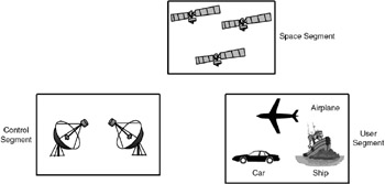
Figure 32.1: Global Positioning System.
-
Space segment
-
Control segment
-
User segment
Space segment: The space segment of GPS consists of 24 NAVSTAR satellites (including three spare satellites) operational since August 1995. These satellites orbit at 20,200 km above the surface of the Earth in six circular orbital planes with a 12-hour orbital period each. These planes are such that from any location on the earth, at least five satellites can be viewed. These satellites operate in the L1 frequency band (1.5742GHz) and continuously broadcast navigational signals. This navigational data can be received by anyone anywhere on the earth free of cost for decoding and finding navigational parameters: location (longitude, latitude and altitude), velocity and time.
The space segment of GPS consists of 24 NAVSTAR satellites, each with an orbital period of 12 hours. These satellites orbit at 20,200 km above the surface of the Earth.
Control segment: The control segment of GPS consists of a master control station (MCS) located at Colorado Springs in the U.S. and a number of smaller Earth stations located at different places around the world. The monitoring stations track GPS satellites and pass the measured data to the MCS. The MCS computes the satellite parameters (called ephemeris) and sends them back to the satellite. The satellites broadcast these parameters to all the GPS receivers.
User segment: The user segment consists of all objects with GPS receivers. The U.S. Department of Defense has not put any restrictions on the use of the GPS receivers; anyone, anywhere on the earth can receive the navigational data through a GPS receiver.
The user segment of the GPS consists of receivers, which calculate the location information using the signals received from the satellites.
| Note | Another global positioning system, called Galileo, is being planned by the European countries. It will be operational in 2007. |
|
| < Day Day Up > |
|
EAN: 2147483647
Pages: 313