Location Technology and LBMS
Location Technology and LBMS
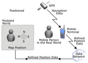
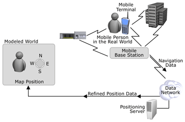
The second requirement is some kind of location technology to determine the position of the mobile terminal. The location in the physical world (measured by the location technology) is communicated via the data communications channel to establish a link with a model of the world, operated by a navigation service provider. As noted, this link and the data communications are fundamental requirements for delivering services conditioned on the location and mobility of the mobile person.
Unfortunately the range of location technologies is at least as broad as the range of data communications technologies. While products such as Microsoft Mobile Information Server exist to shield the service provider from some of the details of the different technologies used for data communications, the navigation service provider must be prepared to deploy a solution to manage the complexity of the underlying location technology. This may be deployed as an identified Position Proxy Server subsystem or as functionality within the NSP s navigation service delivery system. Over the next few years it is likely that standards will evolve, driven by the wireless industry, to make the request for the position of a mobile terminal easy, while protecting the privacy interests of the mobile user.
Unassisted Global Positioning System (GPS) location
There are three categories of location technology:
- Device-borne
- Network
- Observational.
Device-borne positioning depends on systems that transmit time signals or time-difference signals from precisely known orbits (GPS) or fixed locations (LORAN) and use an on-board computation capability to determine the location. These technologies can be easily retrofitted to mobile terminals but at significant cost in terms of parts, weight, and battery consumption. In this case the device "owns" the location.
Network positioning uses the fixed base stations of a communications network to determine the position of mobile terminals in communication range. Several techniques are used, but the net result is that the network operator gets the benefit of economies of scale and the per-mobile terminal cost may be quite low compared to device-borne location technologies. A network operator is very well positioned to use or sell location information because the operator will know the identity and perhaps other information about the terminal and its user in the course of normal business. Network positioning allows the wireless operator to "own" the location.
Observational techniques make use of radio or other observations of mobile terminals to determine their location. This approach may achieve economies of scale, but it lacks a direct business relationship with the mobile users. Also, this approach makes it difficult to identify terminals and match them to their users. The operators of observational location systems "own" the locations.
Assisted GPS positioning can improve precision by a factor of ten
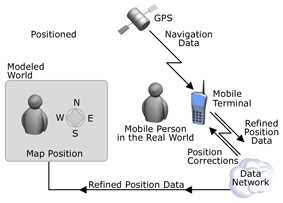
Device-borne location can be made more precise if additional information on system errors is available to allow the onboard system to refine the position information. With current technology, raw GPS positions are available only with good signals from four or more satellites. This is usually only possible outdoors and away from large blocking structures, such as office buildings. Using the data communications capability to access additional computational capability and/or better information on system parameters and systematic errors can improve both the availability and accuracy of GPS locations.
With current technology unassisted GPS positioning using mass-market devices has a precision of ten or twenty meters under good conditions. With differential GPS (DGPS) and other techniques the precision can be improved to perhaps two meters under ideal conditions.
Assisted GPS moves signal processing to the server
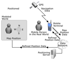
It is possible to split the computational effort of GPS location determination between a device and a remote server. In such assisted GPS configurations the essential information is the signal as received by the mobile terminal from each of the visible GPS satellites. The signal contains information that allows estimation of the time the message was transmitted from the satellite. Knowing the time that the signal is received by the mobile terminal allows estimation of the travel time of the message and hence the distance from each satellite to the mobile terminal. If the signal processing needed to recover the message from the received signal can be moved to the server, then much greater computational power and other techniques can be used to obtain a location that is much more precise than that possible by a device on its own. Precisions of less than a meter are possible as well as operation in signal conditions that would prevent an autonomous system from functioning at all.
Assisted GPS is the first case we have considered where the device does not "own" and control the location information. There are a number of techniques that use the time of travel of signals from the base stations of the mobile service provider (or from the device to those base stations), sometimes in combination with knowledge of the relative signal strength as measured by different antennas at a single ground location or multiple ground locations.
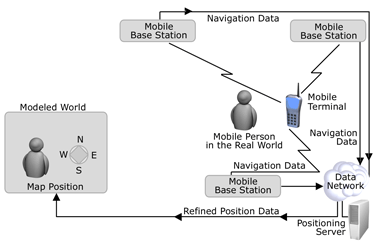
Network location determination gives location to the wireless operator
A network operator can monitor the location of many thousands of mobile terminals simultaneously. Since the location information can be aggregated by the operator across a whole network, the operator can provide access to the location of mobile terminals through a Positioning Proxy Server (PPS). A PPS can hide the underlying location technology and allows use of map-matching, blunder removal, filtering, and predictive techniques enabling the operator to offer a high quality positioning service to LBMS providers and others. Unfortunately, today s implementations are quite imprecise in comparison with GPS technology, typically 100 meters to 1 km or greater. This precision seriously limits the usefulness of network locations. This is a point that implementers of navigation service systems must take into account. Positioning Proxy servers seem to be needed to support buddy-finding and many other interesting mobile applications. Building a PPS into a delivery system has many advantages.
Observational location technology lacks consumer relationship
Observational approaches to location allow the operator to control access to location information, but they lack the link to the identity of the mobile terminal. Even worse, they do not routinely carry data communications with the mobile terminals. The result is that the usability of the location information is limited to aggregated properties of the motion of anonymous mobile terminals. This provides information on travel rates, for example the speed of traffic on roads or pedestrian traffic in a shopping area. It is not particularly useful for delivering generic location based services.
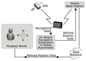
Automobiles have good positioning
Earlier we identified mobile phones and in-car systems as the two important mass-markets for location-based mobile services. In-car devices often have an advantage over phones and other less computationally capable devices because they typically have a combination of GPS sensor data, on-board inertial sensors such as accelerometers, gyroscopes, and speed sensors that allow the determination of very accurate positions at a very high repetition rate (tens of measurements per second). This enables an in-car system to operate in almost any environment.
Of course, one of the reasons cars are outfitted with this extra (expensive) equipment is because the navigational task is more difficult in a car moving at up to 60 meters per second. The consequences of error are potentially more disastrous than providing personal navigation services to a walking person.
There is already a market for the position information from cars, and functional elements corresponding to a PPS are often included in commercial systems. The primary use of the location information is to estimate current traffic speeds based on recent or historical observations of vehicle motion.
| Previous Next |
EAN: 2147483647
Pages: 483