The PIDF-LO
In the GEOPRIV model, there is a difference between location information and its representation. Location information refers to only the data that describe a location, but a location object can contain far more information.
The PIDF Location Object (PIDF-LO) is the object defined in Reference 5 for the representation of location information. The PIDF-LO is simply a PIDF document with one tuple that includes location information. Because PIDF is designed to be very flexible, PIDF-LO can suffer from cardinality problems; location information can be included multiple times in different forms, which could confuse the location user. Care should be taken when constructing a PIDF-LO to ensure that the correct location information is used (see Reference 6).
The following example shows the most basic components of a PIDF-LO:
<?xml version="1.0"?> <pidf:presence xmlns:pidf="urn:ietf:params:xml:ns:pidf" xmlns:gp="urn:ietf:params:xml:ns:pidf:geoprivl0" xmlns:gml="http://www.opengis.net/gml" entity="pres:alice@example.com"> <pidf:tuple > <pidf:status> <gp:geopriv> <gp:location-info> <gml:Point srsName="urn:ogc:def:crs:EPSG::4979"> <gml:pos>-43.5723 153.21760 35</gml:pos> </gml:Point> </gp:location-info> <gp:usage-rules> <gp:retransmission-allowed>no</gp:retransmission-allowed> <gp:retention-expiry> 2006-06-23T04:57:29Z </gp:retention-expiry> </gp:usage-rules> </gp:geopriv> </pidf:status> <pidf:contact>sip:alice@240.24.53.107</pidf:contact> </pidf:tuple> </pidf:presence>
Location Information Types
The most important part of a PIDF-LO is the part that contains the location information. In XML, this is the location-info element. Location information is usually described in one of two forms: geodetic location information, which describes a location using coordinates, such as latitude and longitude; and civic addresses, which use features that are more readily recognized by people, such as countries, cities, streets, and house numbers.
Geodetic Location Information
Geodetic location information is based on coordinate systems, most commonly those that include latitude, longitude, and sometimes altitude. Geodetic location information is usually derived from technologies that locate wireless devices, although the location of fixed devices may occasionally be represented using geodetic coordinates.
Geodetic coordinates can represent virtually any location on, in, or near the planet. Geodetic coordinates are also easily understood by computer software because they only include a small amount of information and that information requires very little knowledge to understand-in other words, the user of geodetic coordinates only has to understand the Coordinate Reference System (CRS). For PIDF-LO, applications need only understand the two- and three-dimensional versions of the World Geodetic System (WGS) 1984 CRS, also known as WGS 84. WGS 84 is the CRS used by the GPS system and it is in wide use in existing cellular location systems.
The simplest geodetic location is a single point. The following PIDF-LO fragment shows the location 43.5723°S, 153.21760°E at an altitude of 35 meters:
<gp:location-info> <gml:Point srsName="urn:ogc:def:crs:EPSG::4979"> <gml:pos>-43.5723 153.21760 35</gml:pos> </gml:Point> </gml:location-info>
WGS 84 defines three Coordinate Reference Systems. The first is a Cartesian system that is centered on the Earth's core. This system is rarely used outside of calculations. The second and third CRSs use more familiar latitude and longitude, or latitude, longitude, and altitude values, and both are based on the WGS 84 ellipsoid.
Altitude in WGS 84 is measured in meters above the WGS 84 ellipsoid. The WGS 84 ellipsoid is a slightly squashed sphere that is chosen for its mathematical properties as well as being a reasonable approximation for the shape of the earth. Since the Earth isn't perfectly round, altitude above the WGS 84 ellipsoid can differ from the actual altitude above mean sea level by up to 100 meters (this occurs near Sri Lanka).
In a PIDF-LO document, geodetic location information is encoded using the Geography Markup Language (GML) version 3.1.1 (see Reference 7). GML is a rich and complex XML grammar for describing geographic features and it can be used to encode a wide range of information. The limited set of GML for use within PIDF-LO is described in References 7 and 8.
One advantage of geodetic location information is its ability to represent uncertainty. Uncertainty arises when a location determination method is imprecise. For instance, a simple and widely used method for determining the location of a wireless device uses the location of the radio transmitter. However, the device is rarely, if ever, right next to the actual transmitter. In fact, it could be anywhere up to several kilometers away. A geodetic location can include this information by describing an area instead of a point-for example, a circular area centered on the transmitter, as in the following:
<gp:location-info> <gs:Circle srsName="urn:ogc:def:crs:EPSG::4326"> <gml:pos>-43.5723 153.21760</gml:pos> <gml:radius uom="urn:ogc:def:uom:EPSG::9102"> 4432 </gml:radius> </gs:Circle> </gml:location-info>
A small set of shapes suitable for representing uncertainty are defined for PIDF-LO in Reference 8. These shapes include both two dimensional areas and three dimensional volumes. The majority of these shapes are currently used in cellular networks to accommodate uncertainty in wireless location technologies. These shapes are shown in Figure 2.7.
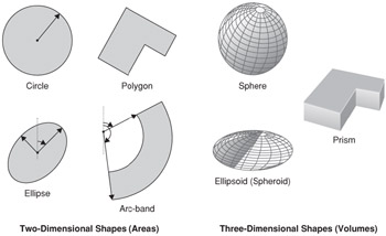
Figure 2.7: Shapes for the representation of uncertainty in PIDF-LO.
Point
The point type represents a location with no uncertainty or a point where uncertainty is not applicable. A point can be specified in either two or three dimensions, using a different Coordinate Reference System (CRS) code for each. In three dimensions, latitude, longitude, and altitude are specified, whereas in two dimensions the altitude is omitted:
<gp:location-info> <gml:Point srsName="urn:ogc:def:crs:EPSG::4326" xmlns:gml="http://www.opengis.net/gml"> <gml:pos>-43.5723 153.21760</gml:pos> </gml:Point> </gp:location-info>
The point is not really a shape, but is included because of its wide applicability.
Circle and Sphere Shapes
The circle and sphere shapes take a point and add an uncertainty radius. The circle is a two-dimensional version that does not include an altitude, implying that the uncertainty is unknown. A sphere, on the other hand, uses a three-dimensional point.
<gp:location-info> <gs:Sphere srsName="urn:ogc:def:crs:EPSG::4979"> <gml : pos>42.5463 -73.2512 17</gml:pos> <gml : radius uom="urn:ogc:def:uom:EPSG::9001"> 850.24 </gml:radius> </gs:Sphere> </gp:location-info>
Circles and spheres are useful in cases where the target is known to be within a certain distance from a fixed point. This is particularly useful for wireless systems, where a transmitter location and maximum range is known.
Ellipse and Ellipsoid Shape
The ellipse and ellipsoid are more specialized versions of the circle and sphere that permit more accurate representation of an area of uncertainty.
The ellipse is represented as a center point, half the length of two axes (semi-major and semi-minor) and an angle of orientation. An ellipse is a two-dimensional shape, therefore it uses a two-dimensional point as a center point. Figure 2.8 shows these parameters and how they apply to the elliptical shape.
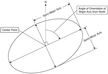
Figure 2.8: An ellipse is a two-dimensional conical section.
The following XML might be used to describe the ellipse shown in Figure 2.8:
<gp:location-info> <gs:Ellipse srsName="urn:ogc:def:crs:EPSG::4326"> <gml:pos>42.5463 -73.2512</gml:pos> <gs:semiMajorAxis uom="urn:ogc:def:uom:EPSG::9001"> 12.75 </gs:semiMajorAxis> <gs:semiMinorAxis uom="urn:ogc:def:uom:EPSG::9001"> 6.70 </gs:semiMinorAxis> <gs:orientation uom="urn:ogc:def:uom:EPSG::9102"> 43.2 </gs:orientation> </gs:Ellipse> </gp:location-info>
The ellipsoid is the three-dimensional version of the ellipse. The center point is specified with an altitude and a height value is added. The ellipsoid shown in Figure 2.9 shows how these parameters are used to describe a three-dimensional shape.
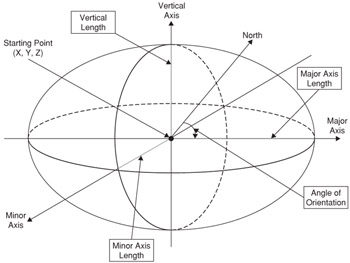
Figure 2.9: The ellipsoid shape adds a third dimension by including a height parameter.
The XML for the ellipsoid is very similar to that for the ellipse:
<gp:location-info> <gs:Ellipsoid srsName="urn:ogc:def:crs:EPSG::4979"> <gml:pos>42.3267 -73.0192 26.3</gml:pos> <gs:semiMajorAxis uom="urn:ogc:def:uom:EPSG::9001"> 7.7156 </gs:semiMajorAxis> <gs:semiMinorAxis uom="urn:ogc:def:uom:EPSG::9001"> 3.31 </gs:semiMinorAxis> <gs:verticalAxis uom="urn:ogc:def:uom:EPSG::9001"> 28.7 </gs:vertica1Axis> <gs:orlentation uom="urn:ogc:def:uom:EPSG::9102"> 43.2 </gs:orientation> </gs:Ellipse> </gp:location-info>
Note that the orientation of the ellipsoid is limited to one value, which constrains the rotation to the horizontal plane. The major and minor axes always lie along the Earth's surface. Three angles would be necessary to provide full control over the orientation of the ellipse. This representation simplifies the specification of ellipsoids and improves interoperation with existing wireless standards, such as those used by 3GPP (see Reference 9) and OMA (see Reference 10).
An ellipse or ellipsoid shape is a common result of triangulation (or trilateration) and algorithms, so these shapes are useful for wireless and GPS location determination methods. An ellipse can also be used in place of a circle in wireless, when a directional antenna is used.
Polygon and Prism Shape
The polygon shape is described as a series of at least four points that define an enclosed area. The first and last points in this series must be the same.
Unlike most of the other two-dimensional shapes, polygons can be defined using either two- or three-dimensional points, but the three-dimensional points are usually reserved for when a polygon is used as the base of a prism.
<gp:location-info> <gml:Polygon srsName="urn:ogc:def:crs:EPSG::4326"> <gml:exterior> <gml:LinearRing> <gml:posList> 42.556844 -73.248157 42.549631 -73.237283 42.539087 -73.240328 42.535756 -73.254242 42.556844 -73.248157 </gml:posList> </gml:LinearRing> </gml:exterior> </gml:Polygon> </gp:location-info>
Polygonal areas are very common in many applications, particularly those relating to civic structures like buildings and fenced allotments of land.
The prism type, shown in Figure 2.10, uses a polygon base and extends it to include a height value. A prism can be used to define a three-dimensional structure, which is very well suited to things like the floor of a building.
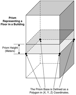
Figure 2.10: A prism is useful in representing a floor of a building.
The XML for a prism encloses the polygon shape as follows:
<gp:location-info> <gs:Prism srsName="urn:ogc:def:crs:EPSG::4979"> <gs:base> <gml:Polygon> <gml:exterior> <gm1:LinearRing> <gml:posList>
42.556844 -73.248157 36.6 42.549631 -73.237283 36.6 42.539087 -73.240328 36.6 42.535756 -73.254242 36.6 42.556844 -73.248157 36.6 </gml:posList> </gm1:LinearRing> </gml:exterior> </gml:Polygon> </gs:base> <gs:height uom="urn:ogc:def:uom:EPSG::9001"> 2.4 </gs:height> </gs:Prism> </gp:location-info>
The one catch with prisms is that the points of the polygon need to be specified in an anti-clockwise direction, otherwise the height is inverted. This is due to the way that the upwards direction is derived in three dimensions.
Arc-Band Shape
The arc-band shape is a shape type that is used in some wireless location determination methods where a target can be located a certain distance from a fixed point, usually a wireless transmitter. This shape results when a location can be determined to between two ranges and between two angles.
The arc band is a two-dimensional shape only, and is defined by a point, a minimum and maximum radius, a start angle, and an opening angle. Figure 2.11 shows how this shape is constructed.
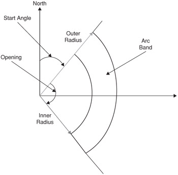
Figure 2.11: An arc-band shape and its defining parameters.
The XML representation of an arc band might appear as follows:
<gp:location-info> <gs:ArcBand srsName="urn:ogc:def:crs:EPSG::4326"> <gml:pos> 42.5463 -73.2512 </gml:pos> <gs:innerRadius uom="urn:ogc:def:uom:EPSG::9001"> 1661.55 </gs:innerRadius> <gs:outerRadius uom="urn:ogc:def:uom:EPSG::9001"> 2215.4 </gs:outerRadius> <gs:startAngle uom="urn:ogc:def:uom:EPSG::9102"> 266
</gs:startAngle> <gs:openingAngle uom="urn:ogc:def:uom:EPSG::9102"> 120 </gs:openingAngle> </gs:ArcBand> </gp:location-info>
Civic Address Location Information
Civic addresses are locations that are suited for human use. A civic address includes countries, cities, suburbs, streets, house numbers and any information that might assist someone in finding a location. A civic address is not always helpful. Outside of towns and cities, geodetic coordinates are likely to be more precise. However, to a person, a civic address is almost always more useful than a set of coordinates.
The civic address format for PIDF-LO has been revised from its original form in Reference 5 to include a larger number of fields. The revised civic format is defined in (see Reference 11). The following example shows a few of the possible fields:
<gp:location-info> <ca:civicAddress xml:lang="en-AU" xmlns:ca="urn:ietf:params:xml:ns:pidf:geopriv10:civicAddr"> <ca:country>AU</ca:country> <ca:A1>New South Wales</ca:A1> <ca:A3>Wollongong</ca:A3> <ca:A4>North Wollongong</ca:A4> <ca:RD>Flinders</ca:RD> <ca:STS>Street</ca:STS> <ca:RDBR>Campbell Street</ca:RDBR> <ca:LMK>Gilligan's Island</ca:LMK> <ca:LOC>Corner</ca:LOC> <ca:NAM>Video Rental Store</ca:NAM> <ca:PC>2500</ca:PC> <ca:ROOM>Westerns and Classics</ca:ROOM> <ca:PLC>store</ca:PLC> </ca:civicAddress> </gp:location-info>
The exact form and content of civic addresses can vary greatly between countries, so the civic address format for PIDF-LO contains a large number of fields. A civic address always contains a country code, which is an ISO 3166 two-letter code, as is used for Internet domain names (for example, JP for Japan, AU for Australia, ES for Spain).
The country code is then followed by an ordered set of fields that have different meanings depending on the country. These fields start with Al, which is the largest national subdivision; A2 is a subdivision of A1; and likewise, A3 through to A6 are each subdivisions of the preceding division. These generic names allow for an interpretation that reflects the civic organization of an individual country. Table 2.1 shows several such country-specific interpretations, as specified in Reference 12.
| Field | Canada (CA) | Japan (JP) | Korea (KO) | United States (US) |
|---|---|---|---|---|
| A1 | province | metropolis (To, Fu) or prefecture (Ken, Do) | province (Do) | state |
| A2 | county | city (Shi) or rural area (Gun) | county (gun) | county, parish, or borough |
| A3 | city or town | ward (Ku) or village (Mura) | city or village (ri) | city or town |
| A4 | town (Chou, Machi) | urban district (gu) | community place name | |
| A5 | city district (Choume) | |||
| A6 | block (Banchi, Ban) |
Beyond the A-elements, a civic address contains a large number of fields for the representation of streets, or thoroughfares. The thoroughfare fields are described in more detail in Reference 12.
The civic address format contains fields that can be used to specify a location quite precisely. Uncertainty does not apply to civic addresses in the same way that it does to geodetic locations. For a civic address, uncertainty is always implicit, and is expressed by excluding those fields that are not known.
The civic address format also includes fields that help a person find a particular location-for example, the LMK field can be used to describe a nearby landmark. A more complete list of acceptable fields can be found in 13.
Because civic addresses are designed for people, they are often difficult for machines to interpret. A computer system that interprets a civic address needs to understand what each component of the address means for its application. This usually requires a database that includes information on towns, streets, and all of the civic address components. Take an application that displays a civic address on a map as an example: to determine where to plot the civic address, the application needs to convert it into coordinates, which requires an extensive database that includes data on every possible civic address. Applications that consume civic address information are either very limited in what they accept, in the region they cover or the allowed fields, or they have massive databases of information.
PIDF-LO Privacy Requests
PIDF-LO defines a number of fields that determine how a Location Recipient is expected to handle the data. In the PIDF-LO document, these requests are contained within the usage-rules element. These privacy-related fields include the following:
-
retransmission-allowed This field indicates whether the Location Recipient should or should not give the PIDF-LO to anyone else.
-
retention-expiry This time indicates a time beyond which the Location Recipient should not store the PIDF-LO.
-
ruleset-reference This URI refers to a document that describes a more complete set of rules which the Location Recipient is asked to respect.
-
note-well This note contains a request to a human viewer of the location information.
It is important to note that these fields are requests only; a dishonorable Location Recipient can easily disregard these requests if they so choose. This is why the rules that are provided to the Location Server are important-the Location Server can ensure that only trusted Location Recipients can receive a PIDF-LO document.
EAN: 2147483647
Pages: 129