Chapter 5. Mobile Positioning
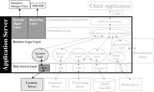
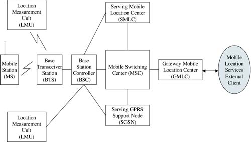
| In addition to having a high-quality map database and a massively scalable suite of tools to perform spatial analyses such as routing and POI lookups, for a mobile locations services solution to be effective it must be possible to look up and pinpoint a user 's location. A discussion of mobile positioning completes our focus on the location-specific components of your mobile location services infrastructure, as shown in Figure 5.1. Figure 5.1. Location Server Components of a Mobile Location Service Architecture. There are a variety of positioning solutions available, which can be broken into three groups: handset-based positioning methods, network-based positioning methods, and hybrid positioning methods (a combination of handset- and network-based positioning). The various solutions have a general trade-off between speed of location determination and accuracy. Depending on the application you are developing, accuracy might be more important than speed or vice versa. For example, if you have an application for deployment on mobile phones that allows a user to look up the nearest coffee shop to his or her location, it might be sufficient to use the latitude and longitude of the cell that the user is calling from as the user's location. It might also be preferable to return a list of potential matches as soon as possible rather than wait for a GPS reading. In some cases, both speed and accuracy might be important. A mobile location services application designed for an in-vehicle system in Europe requires very accurate positioning responses because roads are so narrow and close together. It also requires very fast responses because of the speed of the moving vehicle. Figure 5.2 builds on the GSM architecture diagrams introduced in Chapter 2 and illustrates a sample positioning server architecture. Your applications will interface with the gateway mobile location center (GMLC) to request the location of a mobile device in the network. Selecting a standards-based interface such as the Mobile Location Protocol from the LIF is best (see Appendix C for the complete specification). The GMLC is able to request registration information from the HLR so that it communicates with the correct serving mobile location center (SMLC). The SMLC coordinates and schedules the resources required to position the mobile device and calculates the final location estimate. The SMLC also controls several location measurement units (LMUs) that obtain radio interface measurements from the MS. The LMU devices are either connected to the BTS via the normal GSM air interface or connected to the BSC via the interface used to connect BTSs. Once an MS has been positioned successfully, the GMLC returns the location estimate to the mobile location services external client. Figure 5.2. Positioning Server Architecture in GSM. This chapter discusses the various positioning methods and their advantages and disadvantages. The discussion is fairly elementary ”further technical reading can be found in the References section. We also discuss briefly the differing requirements for accuracy and speed between mobile location service applications. Finally, we discuss the positioning server standards proposed by the LIF and how to integrate a positioning server into your location service infrastructure. |
EAN: 2147483647
Pages: 150